Filing a NOTAM for a Rocket Launch
Key
- MSL - Feet above Mean Sea Level
- AGL - Feet above Ground Level
- NM - Nautical Miles
I welcome contributions to this collection of rocketry safety information. Contact me if you have any corrections, suggestions or contributions.
- a phone call to Leidos Flight Service (LFS), or you may
- file online at the FAA eNOTAM II (ENII) system. How to file.
Your COA will include instructions to contact Leidos, the contact number, a specific time frame for filing a NOTAM, and specific location and altitude information authorized by your waiver. The resulting NOTAM may be viewed online at FNS NOTAM Search] shortly after calling in.
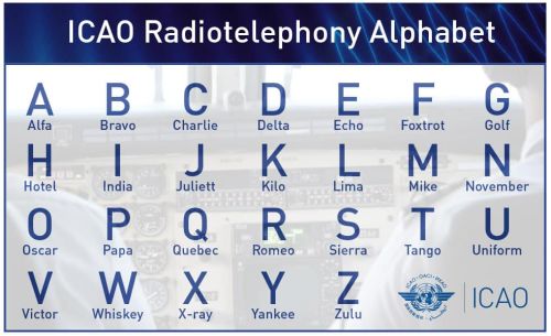
I strongly encourage you to learn the ICAO International Telephony Alphabet. This is an essential communications tool and it makes you sound like a professional. Learning the alphabet is useful in all aspects of communicating with the FAA, military flight operations, and in fact anyone at the other end of your phone or radio call.
Here is sample NOTAM language from my experience.
!ALM 01/009 BWS AIRSPACE UNMANNED ROCKET
WITHIN AN AREA DEFINED AS 1.0NM RADIUS OF
BWS001006(4.6NM NNW ALM) SFC-17000FT YYMMDDHHMM-YYMMDDHHMM
!ALM is the declared airspace (in this case Alamogordo, NM), and 01/009 indicates the 9th NOTAM filed in ALM in January. The term UNMANNED ROCKET is the key identifier or subject of the NOTAM. In this example, BWS is the airspace designated for a nearby airport, and BWS001006 is a location coordinate as a radial from that airport. This helps a pilot plan a flight through the area with an understanding of your launch location with respect to a standard navigation point (that airport). That radial will be called out in your COA. WITHIN AN AREA DEFINED AS nnNM (Nautical Mile) RADIUS OF defines the area within which you are expected to land and recover your rockets. This is the area that flight traffic control will protect by directing traffic around your assigned cylinder of airspace.
The remaining information is the authorized altitude SFCSurface-17000FT, followed by the start and end times for the activity in ZULU Time, which is a Military term for Universal Time Coordinated or UTC, used primarily in aviation and at sea. This is also expressed in 24 hour time, so that e.g. 1:00 pm is 13:00 and 11:55 pm is 23:55. Use this handy converter to supply the ZULU time of your event(s).

